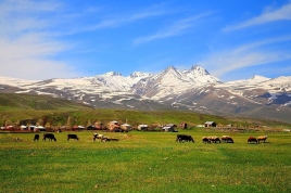
Mount Aragats
Wednesday, November 27, 2024
Mount Aragats is an isolated four-peaked volcano massif in Armenia.
Its northern summit, at 4,090 m (13,420 ft) above sea level, is the highest point of the Lesser Caucasus and Armenia. It is also one of the highest points in the Armenian Highlands.
The Aragats massif is surrounded by Kasagh River on the east, Akhurian River on the west, Ararat plain on the south and Shirak plain on the north. The circumference of the massif is around 200 km (120 mi), and covers an area of 6,000 km2 (2,300 sq mi) or around 1⁄5 of Armenia's total area. 944 km2 (364 sq mi) of the massif is located above 2,000 m (6,600 ft).
According to Armenian tradition, Aragats originates from the words Արա Ara + գահ gah, which translates to "Ara's throne". Ara refers to the legendary hero Ara the Beautiful. Aragats was mentioned by the early medieval historian Movses Khorenatsi, who in his History of Armenia claims that the mountain is named after Aramaneak, the son of Hayk, the legendary father of the Armenian people. Aramaneak called his possessions "the foot of Aragats". The modern Aragatsotn Province, dominated by the mountain, was formed in 1995. The name of the mountain is less often spelled Aragatz or Aragac.
Aragats is isolated from Armenia's other mountain ranges. However, it is considered part and the highest point of the larger Lesser Caucasus mountain range. It has four summits, which are named according to their relative geographic position:
- Northern—4,090 m (13,420 ft)
- Western—3,995 m (13,107 ft)
- Eastern—3,908 m (12,822 ft)
- Southern—3,888 m (12,756 ft)
Mount Aragats has a topographic prominence of 2,143 meters, more than some higher mountains, such as Dykh-Tau (5,205 m high) in Russian part of Great Caucasus Range.
Situated 40 kilometres (25 mi) northwest of Armenian capital Yerevan, Aragats is a large volcano with numerous fissure vents and adventive cones. Numerous large lava flows descend from the volcano and are constrained in age between middle Pleistocene and 3,000 BCE. The summit crater is cut by a 13 kilometres (8.1 mi) long line of cones which generated possibly Holocene-age lahars and lava flows. The volcanic system covers an area of 5,000 km2 and is one of the largest in the region. More recent activity in flank centres occurred in Tirinkatar (0.48-0.61 Ma), Kakavasar, (0.52-0.54 Ma) and Ashtarak (0.58 Ma), as well as Jrbazhan in the summit area (0.52 Ma). The magmas feeding Aragats are unusually hot for arc-derived magmas, resulting in long and voluminous lava flows.


